SL-TF 218 Roque del Conde – Tenerife hiking trail
SL-TF 218 Roque del Conde – Tenerife hiking trail. Photo Adeje ES
Technical information
- Start: Plaza del Cristo de la Salud (Arona)
- Finish: Roque del Conde (Adeje)
- Approval status:
- Degree of difficulty: Intermediate
- Type of trail: Linear
- Distance: 3.7 km (12.89 ft)
- Duration: 2 hours
- Highest altitude: 999 m (12.89 ft)
- Lowest altitude: 596 m (12.89 ft)
- Elevation gain: 484 m (12.89 ft)
- Elevation loss: 149 m (12.89 ft)
- Links to other trails:
- Arona 1 – Casas de Altavista Circular Trail
- Arona 2 – Suarez – El Topo Circular Trail
- GR-131 Anaga – Chasna. Stretch: Vilaflor – Arona
- Protected Nature Areas: Hell’s Ravine Special Nature Reserve
- Authorisation required: No
Trail description
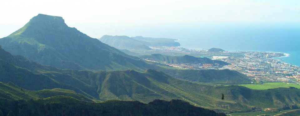
The pathway of Roque del Conde is a farm track that was traditionally used to access different properties, where crops grew in the fields on the hillside and on top of the rock formation. Most of the fields grew cereal, which is clear to see thanks to the various farm terraces on the hillside, the small cluster of houses and the threshing fields at the bottom. The path is still mostly paved with the original stones, which are particularly visible as you cross the El Rey ravine. It is also interesting to note that the Roque del Conde rock formation, together with the two mountain ranges of Anaga and Teno, are the three points where the Island of Tenerife began to form several million years ago. The trail begins in Arona, at the square of El Cristo de la Salud, before heading towards the area known as El Vento, which you can get to along the TF-511 road by turning off roughly 200 yards before kilometre point 3, taking a left along Camino del Vento. The trail follows a beaten earth track, which journeys about 30 yards along a narrow lane, across the Las Arenas ravine and the El Barranco ravine. The trail goes on to reach the El Rey ravine, an abrupt, deep gulley on the border between the municipalities of Arona and Adeje. Right at the start of the El Rey ravine is a path that zig zags down and which still preserves some of the original paving stones. Once you have crossed the ravine of El Rey, the stone paving disappears and the sight revealed ahead of you is a panoramic view of the coast of Granadilla, San Miguel and Arona. Soon, the stone paving reappears underfoot and the trail widens out as it climbs towards the top, surrounded by stone walls and farm terraces. Here again, the stone paving vanishes, as do the stone walls, and the trail continues along a narrow path with a very steep upward slope, right to the top of Roque del Conde, which forms a flat plateau.

SL-TF 218 Roque del Conde Hypsometry
Download free maps Tenerife hiking trail
Also see walking routes:
- Adeje – Barranco del Infierno – Ifonche – Roque Imoque – Roque del Conde – Las Casas
- Adeje — Walk Tenerife
- Arona – Ifonche – Arona Circular
- Arona – Vilaflor
- Costa del Silencio – Tenerife Coastal Escapism
- La Caleta – Tenerife Life in the Raw
- Los Cristianos – Palm-Mar – Las Galletas
- Malpaís de Güímar 1
- Malpaís de Güímar 2
- Malpaís de Güímar 3
- Palm-Mar – Las Galletas
- Piramide de Arona – Playa Las Americas – Puerto Colon
- Playa de Las Americas – La Caleta
- Playa Paraiso – La Caleta
- PR-TF 43 Garachico – Chinyero Mountain
- PR-TF 71 Camino de Teresme
- PR-TF 71.1 Boca del Paso – La Quinta
- PR-TF 71.2 Camino de Ifonche
- PR-TF 72 Vilaflor – Paisaje Lunar – Vilaflor
- SL-TF 60 Santiago del Teide – Arguayo (Almond Blossom Route)
- SL-TF 71 Camino de la Virgen
- Trails in the Teide National Park – paths between volcanoes and rocks
Remember: Prevention, Information and Knowledge are the key to avoiding unpleasant situations.
- Make sure you always have somebody else to walk with, stick to the marked footpaths and respect the way of life, privacy and property of the local inhabitants.
- If you keep your noise levels down, you will discover just how much life there is all around you.
- Take any rubbish with you, even organic waste. This will help preserve the beauty of the scenery and prevent the proliferation of rodents in the area. Take special care with cigarette butts.
- Picking up plants, animals or other items from the environment may entail the loss of irreplaceable resources.
- The people who take care of these Protected Nature Areas would be very grateful if you let them know about any incidents you may have noticed on your walk.
- Remember that the Island’s environment is as unique as it is unpredictable. It must be enjoyed responsibly and sensibly. Take special care in natural areas and don’t forget that accidents can happen at any time.
- Pay attention to signs.
- Check the weather forecast? to make sure the conditions are suitable.
- Wear suitable clothing and footwear for hiking and always pack your mobile phone, sunscreen, a hat, a coat, a waterproof, enough food and plenty of water in your backpack.
- Let your family and/or friends know which route you will be taking and bear in mind how many daylight hours you will need to complete it.